


The use of aerial imagery as a form of remote sensing dates back to the 1800’s, when it was first pioneered by French balloonist Gaspard-Félix Tournachon. Over the years, the technology has advanced from the use of balloons and kites to aircraft and more recently - drones. Due to these technological advancements, aerial imagery remains a widely used and cost-effective method of remote sensing today, especially in the enterprise business sector.
Aerial imagery refers to photographs or videos taken of the ground or terrain from an elevated position, typically from an aircraft, balloon or drone. This type of imagery provides a bird's eye view of the area being captured and can be used in various fields such as surveying, cartography, urban planning, and environmental monitoring. It’s an important tool for mapping, monitoring land use and changes, and identifying patterns and trends in the environment.
This bird’s eye view of the world is known as an aerial perspective. By placing ourselves in the air and looking down, we are able to create aerial imagery.
Aerial imagery and satellite imagery are both forms of remote sensing, but they have some key differences.
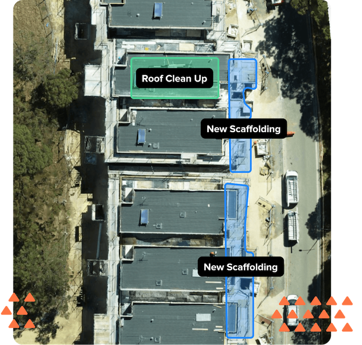
Aerial imagery is captured by cameras mounted on aircraft or drones, which fly at altitudes ranging from a few hundred feet to several miles above the ground. This allows for high-resolution images of small areas with fine details. This is particularly useful in industries such as construction, mining and resources, as well as any industry with a need for asset management and maintenance.
Satellite imagery, on the other hand, is captured by cameras mounted on satellites that orbit the Earth at altitudes of several hundred miles. These cameras can capture images of large areas, often covering entire countries or even continents. The resolution of satellite imagery is generally lower than that of aerial imagery, but it can cover much larger areas.
In summary, aerial imagery is best for capturing high-resolution images of small areas, while satellite imagery is better for capturing large-scale images of entire regions. For this reason, aerial imagery is more popular in mid, large and enterprise business.
See how aerial imagery can help the following industries:
Now that we’ve covered what aerial imagery is, how do you implement it into your mid-large sized business in a scalable and operationally efficient manner? There are two primary ways to implement aerial imagery services in your business, including:
Birdi is a leader in this space.
Again, Birdi is a leader in this space.
Join 1000’s of your peers and subscribe to Birdi’s newsletter today!