Visualize any geospatial data set

View any geospatial data Birdi for accurate insights.
Visualize any geospatial data set in Birdi

Data from any device

Drone icon
Drone
We are drone agnostic, capturing dynamic perspectives for geo-spatial insights.
DSLR icon
DSLR
High-resolution digital cameras for detailed ground-level imaging
Smartphone icon
Phone
On-the-go geospatial data collection.
Pole camera icon
Pole Camera
Extended-reach camera system enabling close-up inspections and mapping.
Helicopter icon
Helicopter
Flexibility to carry various sensors with resolutions.
Vehicle icon
Vehicle
Mobile mapping unit equipped for efficient ground-level geospatial data collection.
Manned aircraft icon
Plane
Fixed-wing aircraft equipped with high-resolution sensor.
Satellite icon
Satellite
High-resolution satellites can provide large scale imagery.
Sonar icon
Sonar
Single and dual beam echo-sounder to map the sea floor.
Drone icon
Drone
We are drone agnostic, capturing dynamic perspectives for geo-spatial insights.
DSLR icon
DSLR
High-resolution digital cameras for detailed ground-level imaging.
Smartphone icon
Phone
On-the-go geospatial data collection.
Pole camera icon
Pole Camera
Extended-reach camera system enabling close-up inspections and mapping.
Helicopter icon
Helicopter
Flexibility to carry various sensors with resolutions
Vehicle icon
Vehicle
Mobile mapping unit equipped for efficient ground-level geo-spatial data collection.
Manned aircraft icon
Plane
Fixed-wing aircraft equipped with high-resolution sensor
Satellite icon
Satelitte
High-resolution satellites can provide very detailed imagery
Sonar icon
Sonar
Single and dual beam echo-sounder to map the sea floor
Drone icon
Drone
We are drone agnostic, capturing dynamic perspectives for geo-spatial insights.
DSLR icon
DSLR
High-resolution digital cameras for detailed ground-level imaging
Smartphone icon
Phone
On-the-go geo-spatial data collection
Pole camera icon
Pole Camera
Extended-reach camera system enabling close-up inspections and mapping.
Helicopter icon
Helicopter
Flexibility to carry various sensors with resolutions.
Vehicle icon
Vehicle
Mobile mapping unit equipped for efficient ground-level geo-spatial data collection.
Manned aircraft icon
Plane
Fixed-wing aircraft equipped with high-resolution sensor.
Satellite icon
Satellite
High-resolution satellites can provide large-scale imagery.
Sonar icon
Sonar
Single and dual beam echo-sounder to map the sea floor.
Drone icon
Drone
We are drone agnostic, capturing dynamic perspectives for geospatial insights.
DSLR icon
DSLR
High-resolution digital cameras for detailed ground-level imaging.
Smartphone icon
Phone
On-the-go geospatial data collection.
Pole camera icon
Pole Camera
Extended-reach camera system enabling close-up inspections and mapping
Helicopter icon
Helicopter
Flexibility to carry various sensors with resolutions
Vehicle icon
Vehicle
Mobile mapping unit equipped for efficient ground-level geo-spatial data collection.
Manned aircraft icon
Plane
Fixed-wing aircraft equipped with high-resolution sensor
Satellite icon
Satelitte
High-resolution satellites can provide very detailed imagery
Sonar icon
Sonar
Single and dual beam echo-sounder to map the sea floor

Easily upload and organize your data

Upload your geospatial data in Birdi

Create flexible map objectives

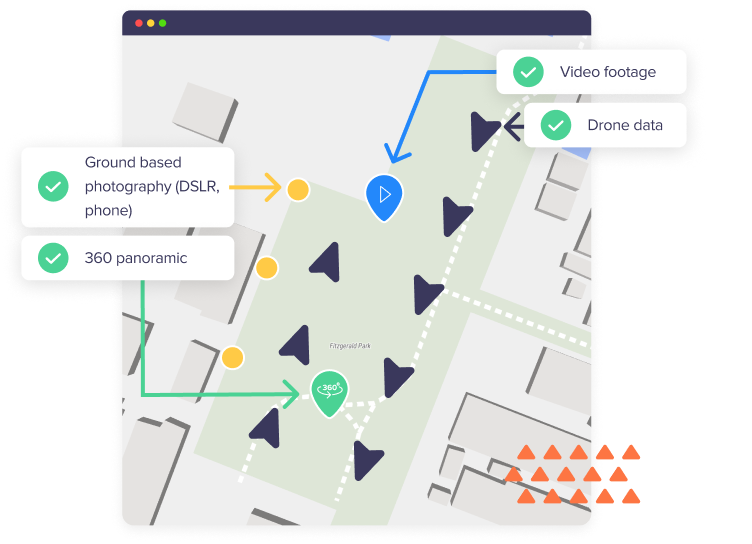
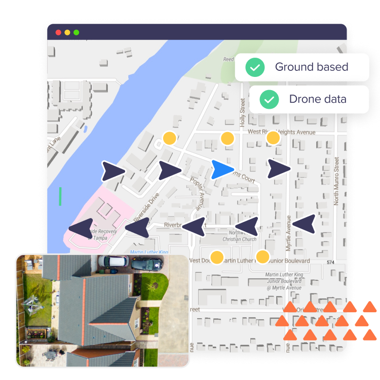
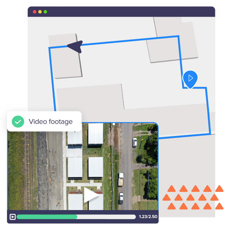
Create a map and upload media from your drone, DSLR or phone, or add existing Geotiffs for visualization.

Upload direct from your device or via a cloud integration

Upload directly from your device or via one of the following cloud solutions: DropBox, OneDrive or Google Drive.

Visualize any geo-referenced file

Images visualized in Birdi
Visualize geo-referenced images
Upload geo-referenced images in JPEG, PNG or RAW formats to visualize them on the map from their precise, captured location.
View the inside of buildings
Use ground-based photography from smart phone or DSLR to visualize the inside of buildings in Map View.
Drone capture location, orientation and pitch
On drone-captured imagery, view image meta data for additional details about the capture (e.g. orientation and pitch).
360 degree panoramas visualized in Birdi
Create an immersive experience
Visualize 360-degree panoramas in Map View. Immerse yourself in the captured environment with support for various file types, including JPEG, PNG, and RAW.
Give greater context to each location
With 360 degree panoramas, gain greater context and clarity on the captured location without physically having to be there.
Videos visualized in Birdi
Easily track video capture location in real time
With video tracking, you can easily visualize the video’s capture path from start to finish as it’s playing. Upload videos in various formats, including MP4, MOV, RAW, and associate a subtitle track (SRT) for real-time flight path analysis.
Gain further visibility over your sites and assets
Video provides greater context and visibility of the captured environment for informed decision-making.
GeoTIFFs visualized in Birdi
Generate a range of GeoTIFFs through Birdi’s processing
With Birdi’s cloud-based processing, you can request 2D maps (orthophotos) and Elevation Models (DTM, DSM) with ease. Supported formats include GeoTiff, Single-Band GeoTIFF, and Multi-Band GeoTIFF.
Upload your own GeoTIFFs
Have existing maps from another service or platform? Upload them into Birdi and visualize them on the map. Birdi accommodates a variety of GeoTIFF file types, allowing you to seamlessly integrate your own maps into the platform.
Shapefiles visualized in Birdi
Draw on the map with annotation tools
Utilize our annotation tools to draw directly on the map. Create shapefiles around areas of interest and export them individually or in various formats, including GeoJSON, Shapefile, KML, and CSV.
Import and export shapefiles seamlessly
Enjoy easy import and export of shapefiles. Supported formats include GeoJSON, Shapefile, KML, and CSV.
Contours visualized in Birdi
Visualize and assess topography
Get a clear understanding of your terrain’s slopes, peaks, valleys, and other topographical features with contour maps. Graphical lines or contours represent the elevation of a geographic area, with lines representing areas of equal elevation, providing a bird's-eye view of the terrain's shape and structure.
Pointclouds visualized in Birdi
View your outputs as 3D models
Visualize and interact with your pointcloud in a 3D model viewing environment. Explore your data from different angles and perspectives, and gain deeper insights and understanding of your spatial information.
Use measurement tools for greater insights
Use measurement tools to enhance your 3D analyses. These tools include distance, angles, area, and measurement functions for levels and height profiles, and allow you to accurately assess elevation changes and understand the topography of the area you're examining.
Tiled Models visualized in Birdi
Enhance your 3D analysis with tiled models
In geospatial applications, tiled models are commonly used to represent large-scale terrain or city models. Each tile corresponds to a specific geographic area, allowing for efficient visualization and analysis of spatial data.
Compatible file format to export
Representing the surface geometry of 3D objects, mesh models are widely employed in computer graphics. Common formats include OBJ, facilitating detailed visualizations in various industries.

Enhance your insights with base maps

Gain powerful insights with our integrated satellite layer

Enhancing your decision-making with real-time, high-resolution (up to 15cm/px) imagery for a clearer view of your sites.

Explore the surroundings effortlessly with our Street View layer

A straightforward addition featuring road names, providing users with an intuitive and informative navigation experience.

Enhance insights with geospatial base maps

Learn more about our base maps

Import and export maps with ease

Import existing maps for visualization

Importing existing maps for visualization

Enhance your visualization capabilities by importing existing geotiff maps

Have existing maps? Upload and visualize them in Birdi.

Organise map layers how you need

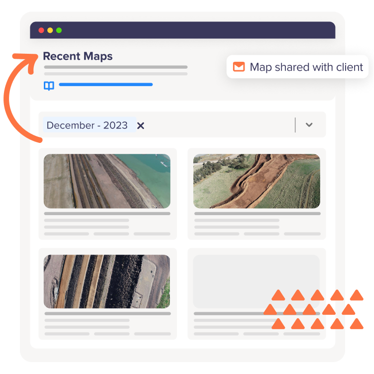
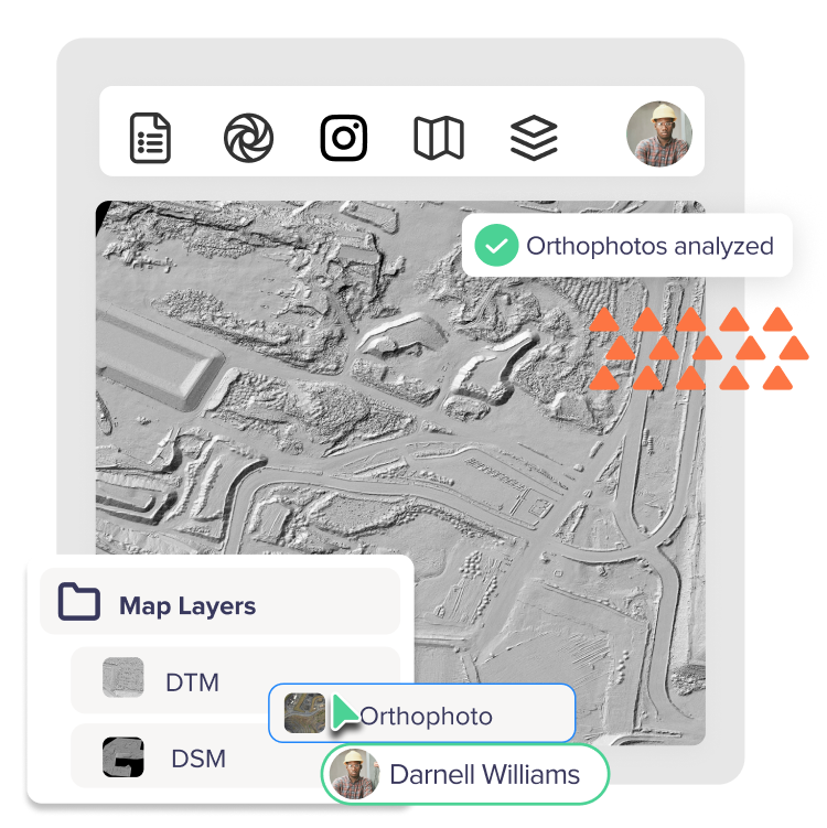
Create folders, customize visibility, and structure your data in the ways that suit you.

Compatible export formats

Compatible export formats with Birdi

Versatile export options

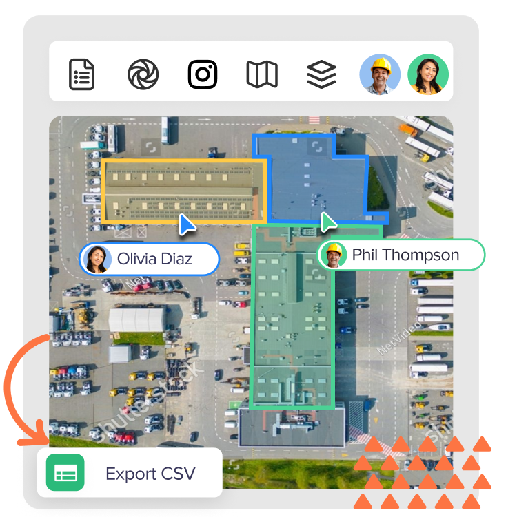
If you need additional insights elsewhere, simply export your data into GeoTIFF or JPEG formats.

Customized export settings

Adjust resolution, compression, and other parameters to achieve the perfect balance between file size and visual fidelity in your exported maps.

Store and share any file

Reliable file hosting

Get up to 1TB of data storage included in your plan to host all of your geospatial data.

Store and share any geospatial file with Birdi